South-western ridge | Mountain hiking | Swiss Alpine Club SAC
Unterstütze den SAC Jetzt spenden

South-western ridge (Normal route) Rote Totz / Roter Totz 2847 m

  • Difficulty
    T4+
  • Ascent
    4–4:30 h, 1250 m
  • Descent
    3–3:30 h, 1250 m

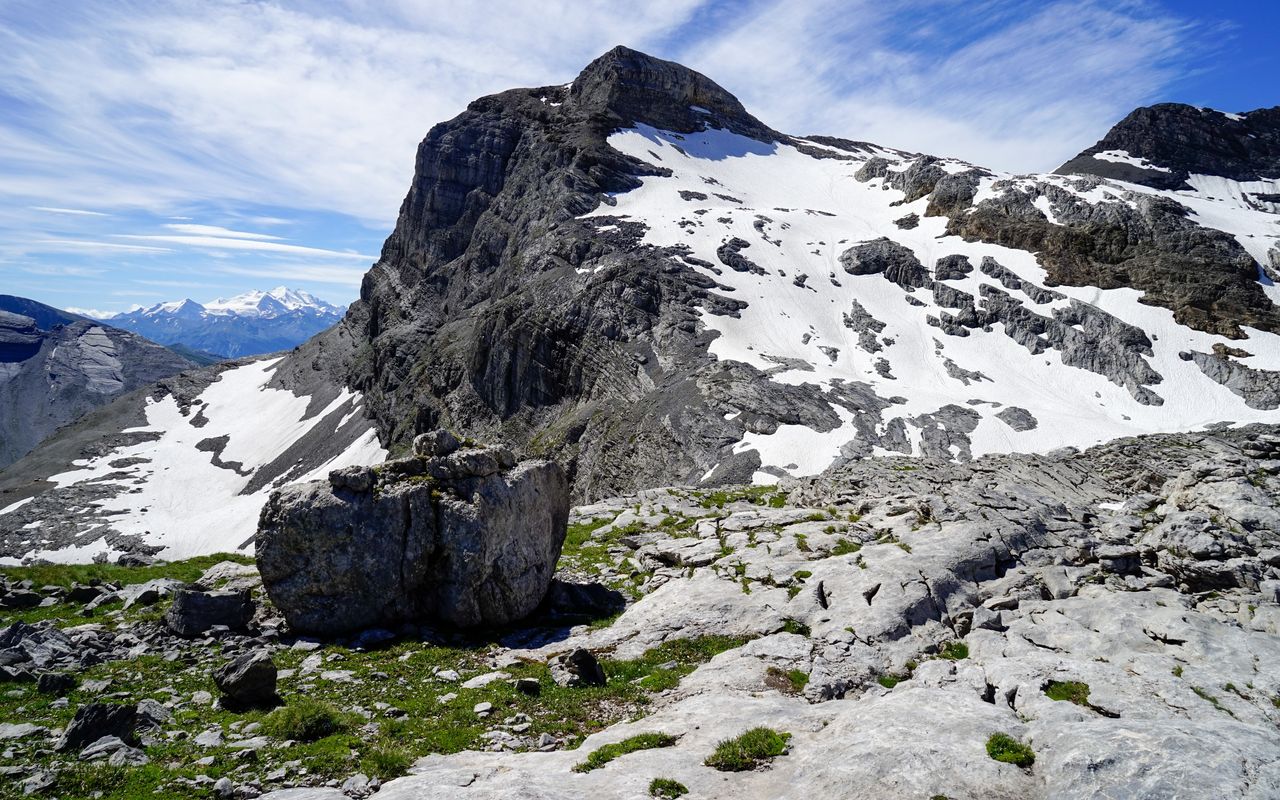
A sea of stone above Gemmipass

Roter Totz is an impressive, but easily accessible rock bastion above Daubensee. The long, varied hike climbs from green meadows up to a vast, barren landscape formed by limestone slabs, scree and the remains of a glacier. While the high valley of Tälligletscher may be snow-covered until late into the summer, Rote Chumme, bathed in the morning sun, can already be hot in spring.

Route description

Sunnbüel – Berghotel Schwarenbach
From Sunnbüel follow the large hiking trail to Berghotel Schwarenbach.
Berghotel Schwarenbach – Rote Chumme – Tälli
On the first turn after crossing Schwarenbach branch off right on the mountain hiking trail leading to Rote Chumme. Climb up the steep and in parts slightly exposed couloir. From the highest point descend westward into Tälli.
Tälli – Rote-Totz-Lücke – Rote Totz and back
At Tälli leave the marked trail and ascend southward on scree (cairns, faint trails) to the remains of Tälligletscher. Continue across the glacier to Rote-Totz-Lücke. The glacier has hardly any crevasses, caution is advised nevertheless. There are a few marking poles on the glacier, while on the névé the trail is normally visible (itinerary to Lämmerenhütte). From Rote-Totz-Lücke go to P. 2830 on the southwestern ridge of Roter Totz, then continue on the ridge to the summit. There are exposed passages on the ridge, but it is easy to walk on. At the end there is a step which needs to be climbed (a few metres II). The step can be avoided on the right (south). Continue to the summit on a faint trail through scree. On the same itinerary go back to Tälli where you left the marked trail on the ascent.
Tälli – Tälliseewli – Schwarzgrätli – Schwarenbach – Sunnbüel
At Tälli ascend slightly right (east) of the creeks, at first pathless or on some footprints, in the direction of Tälliseewli. There you are back on a marked hiking trail, which you follow on the eastern shore of the lake to Waldiswang. From there continue (somewhat rough) below the rocks of Schwarzgrätli on boulder fields to P. 2381. Now descend to Berghotel Schwarenbach and back to Sunnbüel on the hiking trail.
Direct ascent alternative from Rote Chumme to Roter Totz
From the saddle above Rote Chumme you can ascend directly southward towards Rote Totz. An itinerary is marked by cairns, which are, however, not visible before the snow has melted away; that can be as late as late summer. In this case one can find an itinerary on névés and rock slabs to reach the south-western ridge of Rote Totz right before the step that requires climbing. The orientation is slightly more difficult; it saves roughly 20 mins as compared to the main itinerary.

Additional information

Departure and arrival point

Sunnbüel, Bergstation (1934 m)

Summit station of the cable car Eggeschwand – Sunnbüel: www.sunnbuel.ch

Bus service from Kandersteg to Eggeschwand: afabus.ch

Time

The alternative route saves 20 minutes, but might be more difficult depending on the conditions.

Difficulty / Material

The south-western ridge of Roter Totz is moderately exposed, requires, however, surefootedness and no fear of heights. The climbing step before the summit (short passage II) can be avoided on the right-hand side (south). In the environs of Tälligletscher snow can be encountered until late into the summer, so that you might be required to find your own way.

Waypoints

Berghotel Schwarenbach (2060 m)

A place to eat and sleep on the ascent and descent.

Rote Totz Lücke (2802 m)

This is where the rocky passages on the way to Roter Totz begin.

Schwarzgrätli (2381 m)

From here the descent to Schwarenbach or on to Gällihore (neighbour summit) begins.

Wyssi Flue (Üschenen) (2470 m)

An inconspicuous summit, which is traversed on the way to Gällihore (neighbour summit).

Üschenegrat (2387 m)

Along Üschenegrat the neighbour summit Gällihore can be reached.

Neighbor summit

Gällihore / Gällihorn (2282 m)

Small, but nice summit above Sunnbüel, which is very impressive, viewed from Kandersteg. From Sunnbüel the mountain hiking trail is marked. T3. After descending from Rote Totz hikers with stamina continue their hike to Gällihore, following the entire Üschenegrat from Schwarzgrätli (P. 2383).

Felshore / Felsenhorn (2784 m)

From the col across Rote Chumme you hike pathless, but marked by cairns, on slabs and scree to the summit. T3.

Authors

Sabine Joss

Fredy Joss

Sabine und Fredy Joss

Alpine hiking, climbing and other mountain sports Sabine and Fredy Joss's passion. They have been writing and photographing for the SAC publishing house and the club magazine Die Alpen for many years. Sabine is also a biologist and tour guide; Fredy a proofreader and editor for various magazines.

Our recommendations

Walliser Alpen

Alpine Touren

Selection guide

Walliser Alpen

Price CHF 49.00
Member price CHF 39.00
Skitouren Berner Alpen Ost

Skitouren

Skitouren Berner Alpen Ost

Price CHF 44.00
Member price CHF 34.00
SAC-Crocs

Equipment

SAC-Crocs

Price CHF 59.00
Member price CHF 49.00
Klettern Kombipaket Berner Oberland

Klettern

Klettern Kombipaket Berner Oberland

Price CHF 98.00
Member price CHF 79.00
Tourenportal/App-Abo Jahreszahlung

Subscription to the SAC Route Portal

Tourenportal/App-Abo Jahreszahlung

Price CHF 49.00
Gipfelziele Berner Oberland Grossformat

Berg- und Alpinwandern

Gipfelziele Berner Oberland Grossformat

Price CHF 54.00
Member price CHF 45.00
SAC-Hütten-Monopoly

At home

SAC-Hütten-Monopoly

Price CHF 69.90
Member price CHF 60.00
SAC-Taschenmesser

Equipment

SAC-Taschenmesser

Price CHF 54.00
Member price CHF 49.00
Bergsport Sommer

Ausbildung

Bergsport Sommer

Price CHF 59.00
Member price CHF 49.00
Ausbildung Bergwandern / Alpinwandern

Ausbildung

Ausbildung Bergwandern / Alpinwandern

Price CHF 59.00
Member price CHF 49.00
feedback