North-west couloir | Mountain hiking | Swiss Alpine Club SAC
Unterstütze den SAC Jetzt spenden

North-west couloir Mittagflue / Mittagsflue (Boltigen) 1886 m

  • Difficulty
    T5-
  • Ascent
    3:30 h, 1080 m
  • Descent
    2 h, 1080 m

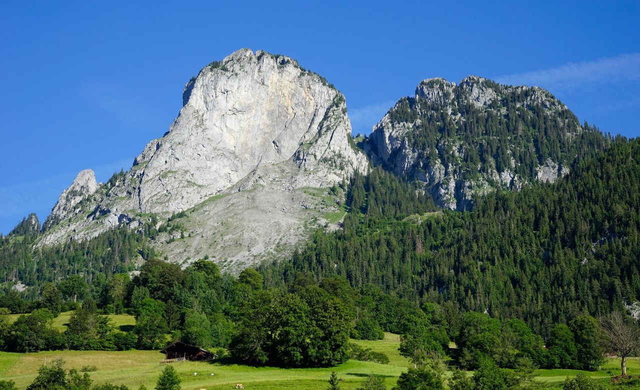
Simmental’s mightiest rock

Whoever is hiking in Simmental must visit Mittagflue at all costs. It is hardly believable that there is a trail up to this rock with its vertical walls on the Simmental side. Admittedly, the trail leads «only» to the secondary summit, and the last bit is rough and steep. More challenging are various couloirs and grassy gullies, through which an interesting itinerary leads up to the summit. It is the main itinerary presented here. Whatever trail you choose, the easier one to the secondary summit or the more difficult one to the main summit: the view from both points is breathtaking.

Route description

Boltigen – Ramsere
From the Boltigen railway station follow the hiking trail, later the mountain hiking trail via Tubetal to Alp Ramsere. The latter can be reached by bike or Alpentaxi.
Ramsere – Saddle P. 1754
On Alp Ramsere leave the trails and ascend the pasture slopes north-westward. An aisle in the forest makes the ascent possible. Over the years, however, the aisle might be overgrown. It leads to the couloir between the rocks of Mittagflue and Holzerhore. The couloir is moderately steep, and the grass next to the gravel is easily walkable. Ascend up to the highest point (P. 1754). So far: T4. Who thinks the couloir between Ramsere and P. 1756 is already steep enough, should not continue through the north-west couloir, but descend 20 meters south-westward to the mountain hiking trail and follow this trail to the summit. (Same time required as for the main route.)
Col P. 1756 – Main summit (1886 m) – Secondary summit (1865 m)
From P. 1754 continue south-westward on the grassy ridge and enter a grassy gully between two cone-shaped rocks. The grassy gully turns left, leading up to one of the cone-shaped rocks. Behind this rock ascend in the fall line of the summit the narrow, very steep gully interspersed with rocks. A few short passages require climbing (I). A distinctive rocky thumb may help with the orientation: to the left (north-east) of this thumb the grassy gully leads up the mountain. As soon as the slope reclines, turn right (south) through fields of mountain roses to reach the main summit (1886 m) within minutes. Descent to the secondary summit: descend south-eastward slightly left of the ridge line to a steeper, rocky zone, which requires roughly three metres of easy (I) climbing down. A few metres up again, and you stand on the secondary summit with its summit cross and summit book (1865 m).
Secondary summit (1865 m) – Nüschlete – Boltigen
The descent from the secondary summit to Boltigen follows the marked mountain hiking trail. The first section is steep and rough with high steps and slippery passages. It leads to Alp Nüschlete and continues below Mittagflue back to Alp Ramsere and on the ascent trail back to Boltigen. This descent is an easier alternative for the ascent on the main itinerary (T3 to the secondary summit with its summit cross and summit book). Short easy climbing (I) on the way up to the main summit. T4. Boltigen–Mittagflue 3 h 30 min.

Additional information

Departure and arrival point

Boltigen (816 m)

An der bls-Linie Spiez – Erlenbach – Zweisimmen und an der tpf-Buslinie Bulle – Charmey – Jaun – Jaunpass – Boltigen.

Difficulty / Material

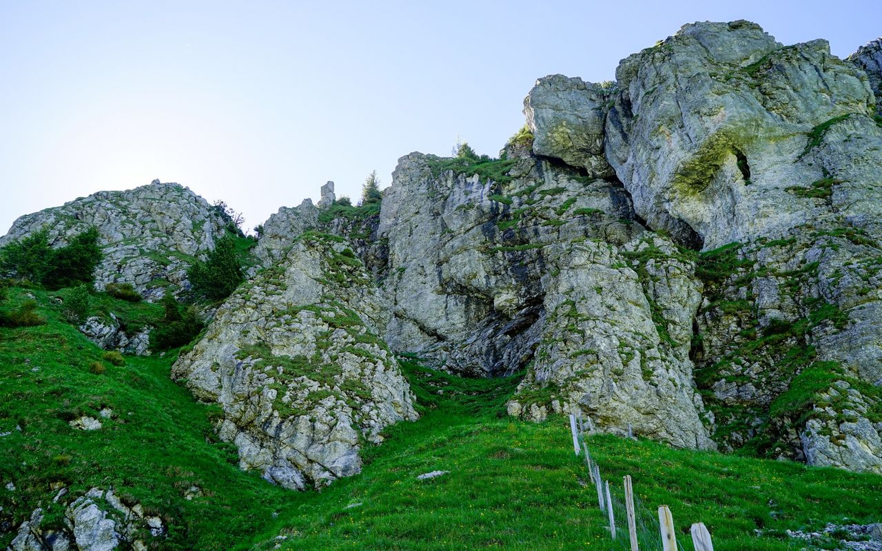
The couloir between Mittagflue and Holzerhore is only moderately steep and fairly easy to walk on. The grassy gullies, however, are very steep and interspersed with rocks, which need climbing (short passages I, T5-). An ice axe can be helpful. With their north-west exposure the grassy gullies below the summit remain wet or icy for a long time. Due to the risk of falling rocks in the couloirs and gullies wearing a helmet is recommended. The variant on the trail to the secondary summit involves a steep final part with high steps, slippery roots and gravel (T3).

Waypoints

Ramsere (1361 m)

Alternative ascent: drive up to Ramsere with the Alpentaxi or mountain bike. When starting from there, you save 1 h 30 min.

Author

Fredy Joss

Sabine und Fredy Joss

Alpine hiking, climbing and other mountain sports Sabine and Fredy Joss's passion. They have been writing and photographing for the SAC publishing house and the club magazine Die Alpen for many years. Sabine is also a biologist and tour guide; Fredy a proofreader and editor for various magazines.

Our recommendations

Skitouren Berner Alpen Ost

Skitouren

Skitouren Berner Alpen Ost

Price CHF 44.00
Member price CHF 34.00
SAC-Crocs

Equipment

SAC-Crocs

Price CHF 59.00
Member price CHF 49.00
Gipfelziele Freiburg

Berg- und Alpinwandern

Gipfelziele Freiburg

Price CHF 54.00
Member price CHF 45.00
Klettern Kombipaket Berner Oberland

Klettern

Klettern Kombipaket Berner Oberland

Price CHF 98.00
Member price CHF 79.00
Tourenportal/App-Abo Jahreszahlung

Subscription to the SAC Route Portal

Tourenportal/App-Abo Jahreszahlung

Price CHF 49.00
En famille vers les cabanes du CAS

Hütten

En famille vers les cabanes du CAS

Price CHF 54.00
Member price CHF 45.00
Gipfelziele Berner Oberland Grossformat

Berg- und Alpinwandern

Gipfelziele Berner Oberland Grossformat

Price CHF 54.00
Member price CHF 45.00
SAC-Hütten-Monopoly

At home

SAC-Hütten-Monopoly

Price CHF 69.90
Member price CHF 60.00
Les Alpes, un monde vivant

Ausbildung

Les Alpes, un monde vivant

Price CHF 64.00
Member price CHF 54.00
SAC-Taschenmesser

Equipment

SAC-Taschenmesser

Price CHF 54.00
Member price CHF 49.00
Hütten der Schweizer Alpen / Cabanes des Alpes suisses

Bildbände

Hütten der Schweizer Alpen / Cabanes des Alpes suisses

Price CHF 69.00
Member price CHF 59.00
feedback