Traverse from Schächental to the Lidernenhütte | Mountain hiking | Swiss Alpine Club SAC
Unterstütze den SAC Jetzt spenden

Traverse from Schächental to the Lidernenhütte (Normal route) Chaiserstock (Lidernen) 2514 m

  • Difficulty
    T4+
  • Ascent
    3:15 h, 1000 m
  • Descent
    1:45 h, 910 m

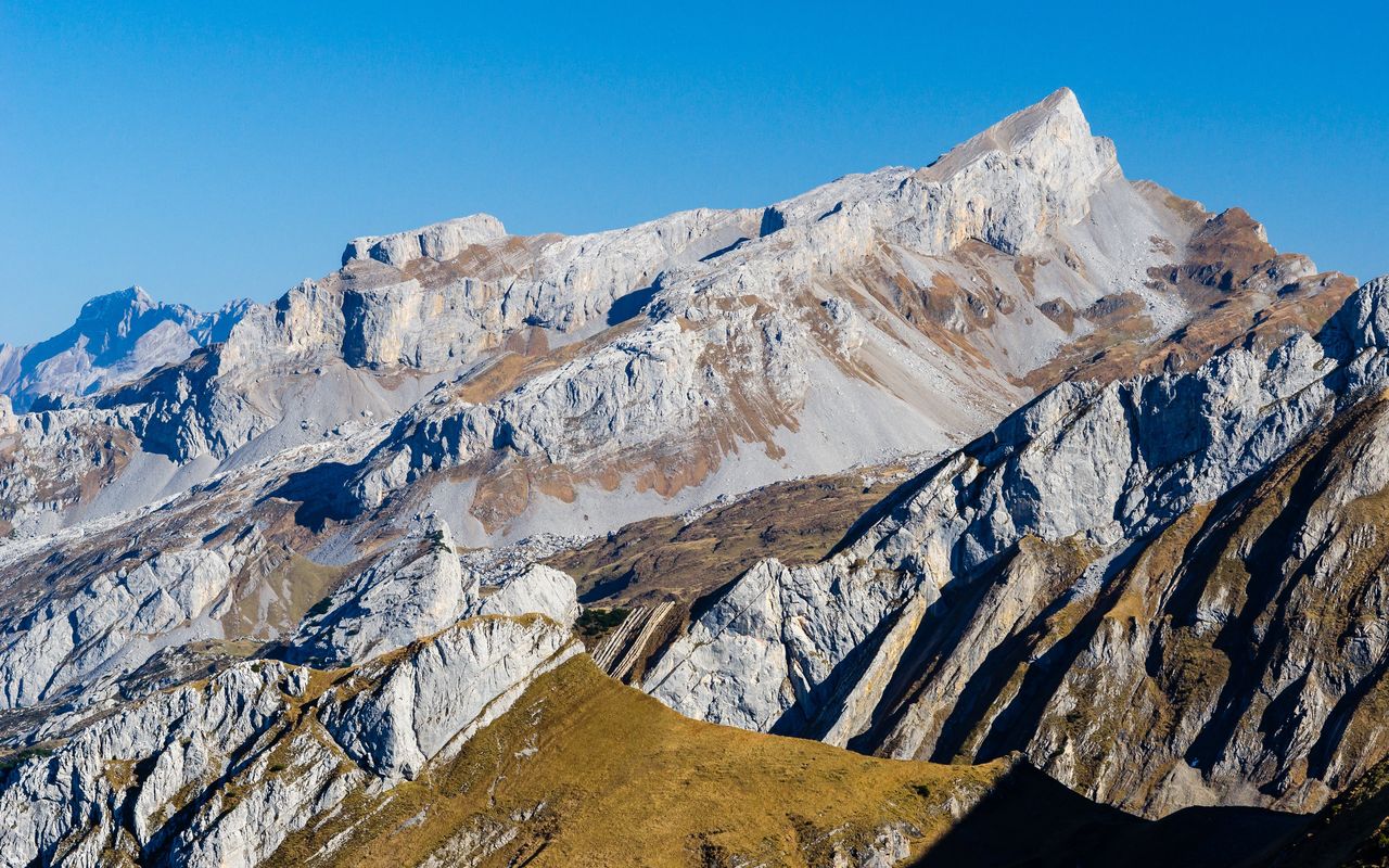
The mini Dolomites of central Zentralschweiz

The landscape at Frutt could hardly be more impressive: the south walls of Chaiserstock, Fulen and Rossstock fall almost vertically from above, into steep scree slopes, which in turn reach down into lush pastures - quite like in the Dolomites. As unapproachable as the peaks may seem, they offer some excellent alpine hiking ventures. We describe firstly the highest and most difficult to climb: the Chaiserstock; the other two summits are included as variants or 'add-ons'.

Route description

Biel – Frutt
From the Biel cable car station follow a marked path northwards, past a chapel, pass Vorder Weissenboden and traverse the flank beneath the cableway to reach a fork at P. 1803. From here take the higher path, which continues onto scree then along the cliff base to a gully leading up to Fruttstägen. Zigzag up the steep gully, being mindful of loose rock, then on up to P. 2075 and the high plateau of Frutt.
Frutt – Liderner Plänggeli
From Frutt (2075 m) follow the well marked footpath NE, shortly up then down to a hut at P. 2076. Turn NW, cross a depression, then ascend once more, diagonally over screes and into a grassy gully. A final 3-metre-high rock step (fixed rope) provides access to the notch on Liderner Plänggeli (2199 m).
Liderner Plänggeli – junction at P. 2271
The track continues from Liderner Plänggeli NE over rocky meadows and several shallow depression - the Chaiserstocksätz - and later turns N once more through scree to a fork at the foot of the Chaiserstocks, at 2271 m.
P. 2271 – Chaiserstock
Continue on to the foot of the Chaisertor. The last 30 vertical metres to the saddle (2338 m) involve some easy climbing (be mindful of falling rocks if groups ahead). Near the Chaisertor, pass a tower on its north side, then follow the northwest ridge. Fixed ropes and chains help to overcome steep passages and steps, but fitness and athleticism are also handy. After 50 meters altitude, the main difficulties are over and a broad rubble humpback leads you up to the summit cross of the Chaiserstock. Descend back down the route of ascent.
P. 2271 – Lidernenhütte
From the footpath junction, take the marked path descending to the right. Passing many tiny pools on route, you'll reach reach the small south wall of the Schmalstöckli (2011 m). From there it's only a short distance to the Lidernenhütte.

Additional information

Departure point

Biel (Kinzig), Bergstation (1626 m)

Informationen zur Seilbahn Büel – Biel (Kinzig): www.biel-kinzigag.ch

End point
Time

Biel – Liderner Plänggeli 2 hrs 15 Min.

Liderner Plänggeli – Chaiserstock 1 hr.

Chaiserstock – Lidernenhütte 1 hrs 45 Min.

Difficulty / Material

Some easy sections of climbing before and after the Chaisertor. The most exposed passages are made safe with ropes or chains, but they are still 'airy' and must be carefully negotiated, also on descent. The approach via Fruttstägen (T3) and the way up to Liderner Plänggeli (one point of T4) are generally easier. Routes are well marked up to Liderner Plänggeli; thereafter less so.

Waypoints

Chaisertor (2338 m)

Obvious gap between the small and big Chaisers

Catering and overnight stay

Biel (Kinzig), Bergstation (1626 m)

Guestouses at Biel: Berggasthaus Biel (by the top cable car station, www.berggasthaus-biel.ch) or Skihaus Edelweiss (on the Vorderes Weissenboden, www.biel-kinzig.ch).

Neighbor summit

Fulen (SZ) (2490 m)

Fulen and Rossstock can be easily added on to and ascent of Chaiserstock. From the Chaiserstock trace your steps back to Liderner Plänggeli and continue along a path under the Fulen's north flank towards the Rossstocklücke (pass). Shortly before the pass, cut back sharply left, follow bands to the north-east, then zig-zag up the north flank to reach Fulen (T4–, marked, avoid with old snow or when wet). Back to the Rossstocklücke, then climb northwest onto the broad grassy ridge and climb this to the summit of the Rossstock. Descent via Mälchbödeli to Gitschen (from Chaiserstock to Gitschen including the two peaks 4 hours).

Rossstock (SZ) (2460 m)

See Description for Fulen.

Author

Marco Volken

Marco Volken is a freelance photographer and alpine journalist. He has co-authored numerous books on the Alpine region, including illustrated books, non-fiction books, hut guides, hiking and club guides, ski touring and climbing guidebooks.

Our recommendations

Gipfelziele Zentralschweiz Vierwaldstättersee

Berg- und Alpinwandern

Gipfelziele Zentralschweiz Vierwaldstättersee

Price CHF 54.00
Member price CHF 45.00
SAC-Crocs

Equipment

SAC-Crocs

Price CHF 59.00
Member price CHF 49.00
Tourenportal/App-Abo Jahreszahlung

Subscription to the SAC Route Portal

Tourenportal/App-Abo Jahreszahlung

Price CHF 49.00
SAC-Hütten-Monopoly

At home

SAC-Hütten-Monopoly

Price CHF 69.90
Member price CHF 60.00
SAC-Taschenmesser

Equipment

SAC-Taschenmesser

Price CHF 54.00
Member price CHF 49.00
Schneeschuhtouren Zentralschweiz

Schneeschuhtouren

Schneeschuhtouren Zentralschweiz

Price CHF 59.00
Member price CHF 49.00
Ausbildung Bergwandern / Alpinwandern

Ausbildung

Ausbildung Bergwandern / Alpinwandern

Price CHF 59.00
Member price CHF 49.00
Hütten der Schweizer Alpen / Cabanes des Alpes suisses

Bildbände

Hütten der Schweizer Alpen / Cabanes des Alpes suisses

Price CHF 69.00
Member price CHF 59.00
feedback