From Morschach via Chälen | Mountain hiking | Swiss Alpine Club SAC
Unterstütze den SAC Jetzt spenden

From Morschach via Chälen Fronalpstock (SZ) 1920 m

  • Difficulty
    T4-
  • Ascent
    3:15 h, 1120 m

Worthwhile tour away from the cable cars.

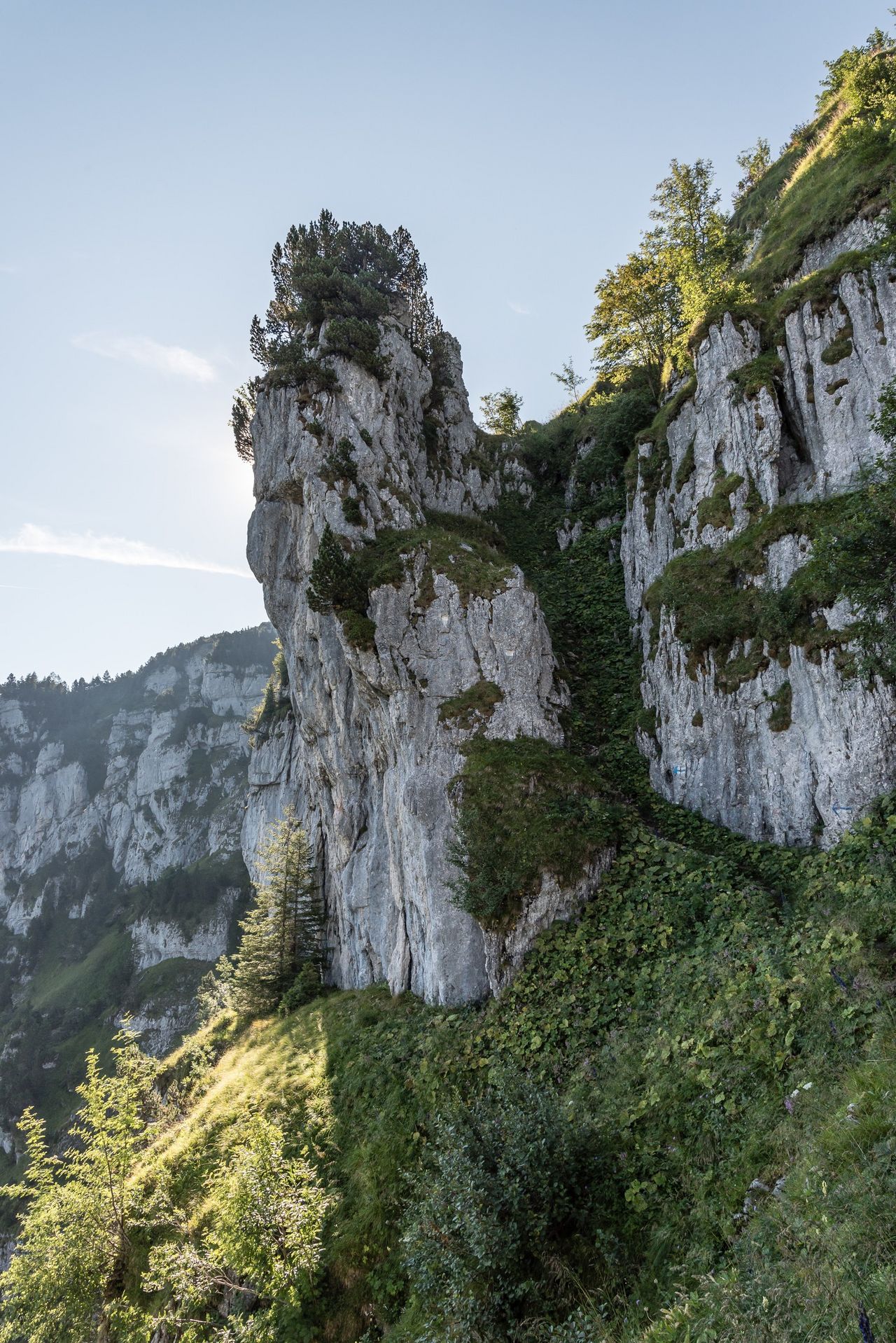
A grand ascent. At first glance the north flank of the Fronalpstock appears somewhat repellent, but it proves an easy climb. Unsurprisingly, the view from the summit is amazing; above Lake Lucerne, the Fronalpstock is known to have one of the best panoramic views in the region.

Route description

Morschach – Eu
From the Morschach cable car station, cross the large car park and follow a path through the meadow to Restaurant Nägelisgärtli (closed during the day). Here, turn left. Pass Ried and continue into the forest. Shortly thereafter, at P. 847, turn left again. After about 10 minutes, at the second of two hairpin bends, leave the forest road and climb southwest through the forest towards the huts of Wissenflue (1013 m). Continue up the steep path, with many switchbacks, to the alpine huts of Eu (1309 m).
Eu – Charenstöckli
From the Eu alpine hut, a right turn brings you to a cross at the edge of a steep drop (Spitzeren). Continue left along the edge. At approx. 1430 m traverse rightwards and then follow the broad, sparsely wooded, partially rocky ridge. At 1580 metres you come to the base of the Chällen, a rock couloir. This is followed by several more leftwards leading channels and ledges, which gradually allow access through the rocky flank. There are some fixed ropes and a small ladder in the middle section which make things easier. At the end of the rock belt, the trail continues eastwards over a sloping meadow (tricky to dangerous with snow). At the end of this, not far from P. 1782 at the foot of the Charenstöckli, you will find a signpost.
Charenstöckli – Fronalpstock
From the foot of the Charenstöckli, the main "highway" will lead you to the summit. Descent from the Fronalpstock can be made by cable car, or on foot in an hour or so on the main well-marked hiking trail.
Variant 1: Starting from Stoos (halfway station)
The approach from the Stoos is less interesting, but takes less time (because it requires less ascent). From the cable car station, follow the mostly horizontal forest road to P. 1169, then gently up on a marked path to Eu (approx. 40 minutes shorter than normal approach).
Variant 2: Descent to Sisikon
Not for sissies! An interesting, adventurous variant: a descent into the Riemenstaldner valley. From the summit follow the broad path down to Furggelen (a col at 1730 m). From here, leave the hustle and bustle and head south. The path is hardly recognisable at first; stick to the middle of the valley when in doubt. At a striking rock pulpit (approx. 1610 m) turn left along a good track, crossing some steep gullies, diagonally down to Alp Huseren (approx. 1445 m). From here a much clearer path leads in a determined zigzag through the stumpy, impressive Huseren forest. This requires sure-footedness as well as a working set of knees. At P. 991 cross a road, continue down to Acherberg then follow the road out of the valley to P. 811 (bus stop). Cross the stream and follow an entertaining, somewhat wild and beautifully shady path down to Sisikon (2 hours 45 minutes from the summit to Sisikon, T4–).

Additional information

End point

Fronalpstock, Bergstation (1906 m)

Informationen zu den Transportanlagen: stoos-muotatal.ch/train/stoosbahnen/

Difficulty / Material

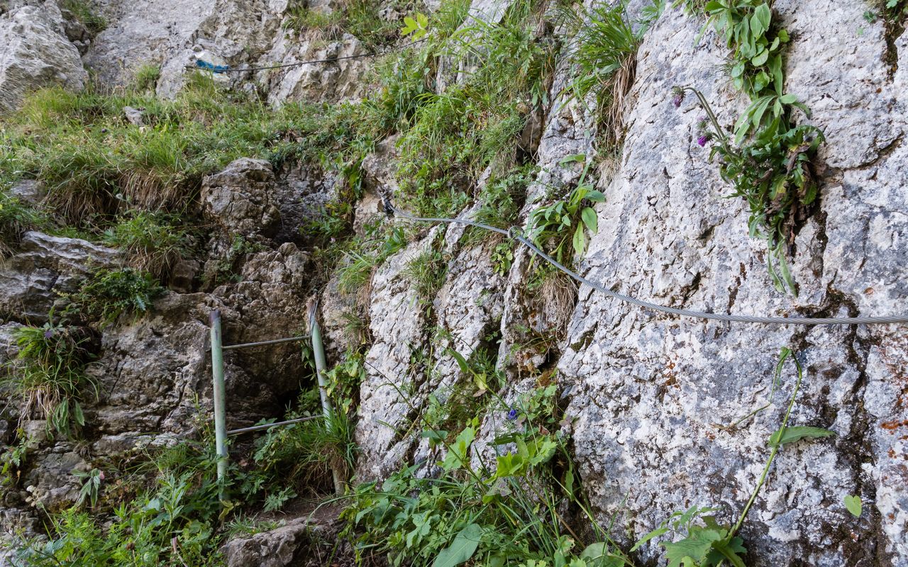
Route marked throughout; from "Eu" with white-blue-white paint. Some easy, ever-so-slightly-exposed bits of scrambling, but these are secured with fixed ropes. Main difficulties limited to around 100 vertical metres. The route is officially closed from late autumn to early summer (some fixed ropes are removed at the end of the hiking season). Due to the shady aspect of the the terrain it is often damp - and it is very tricky with wet or old snow. In dry conditions however, it is an ideal route for all those keen to try alpine hiking.

Waypoints

Stoos SZ, Bergstation (1300 m)

Alternative starting point (variant 1).

Sisikon, Bahnhof (445 m)

Alternative finish (variant 2).

Author

Marco Volken

Marco Volken is a freelance photographer and alpine journalist. He has co-authored numerous books on the Alpine region, including illustrated books, non-fiction books, hut guides, hiking and club guides, ski touring and climbing guidebooks.

Our recommendations

Gipfelziele Zentralschweiz Vierwaldstättersee

Berg- und Alpinwandern

Gipfelziele Zentralschweiz Vierwaldstättersee

Price CHF 54.00
Member price CHF 45.00
SAC-Crocs

Equipment

SAC-Crocs

Price CHF 59.00
Member price CHF 49.00
Tourenportal/App-Abo Jahreszahlung

Subscription to the SAC Route Portal

Tourenportal/App-Abo Jahreszahlung

Price CHF 49.00
SAC-Hütten-Monopoly

At home

SAC-Hütten-Monopoly

Price CHF 69.90
Member price CHF 60.00
SAC-Taschenmesser

Equipment

SAC-Taschenmesser

Price CHF 54.00
Member price CHF 49.00
Schneeschuhtouren Zentralschweiz

Schneeschuhtouren

Schneeschuhtouren Zentralschweiz

Price CHF 59.00
Member price CHF 49.00
Ausbildung Bergwandern / Alpinwandern

Ausbildung

Ausbildung Bergwandern / Alpinwandern

Price CHF 59.00
Member price CHF 49.00
Hütten der Schweizer Alpen / Cabanes des Alpes suisses

Bildbände

Hütten der Schweizer Alpen / Cabanes des Alpes suisses

Price CHF 69.00
Member price CHF 59.00
feedback