Rasa - Gridone - Rifugio al Legn | Mountain hiking | Swiss Alpine Club SAC
Unterstütze den SAC Jetzt spenden

Rasa - Gridone - Rifugio al Legn Gridone / Monte Limidario 2186 m

  • Difficulty
    T3
  • Ascent
    5 h, 1540 m
  • Descent
    4 h, 650 m

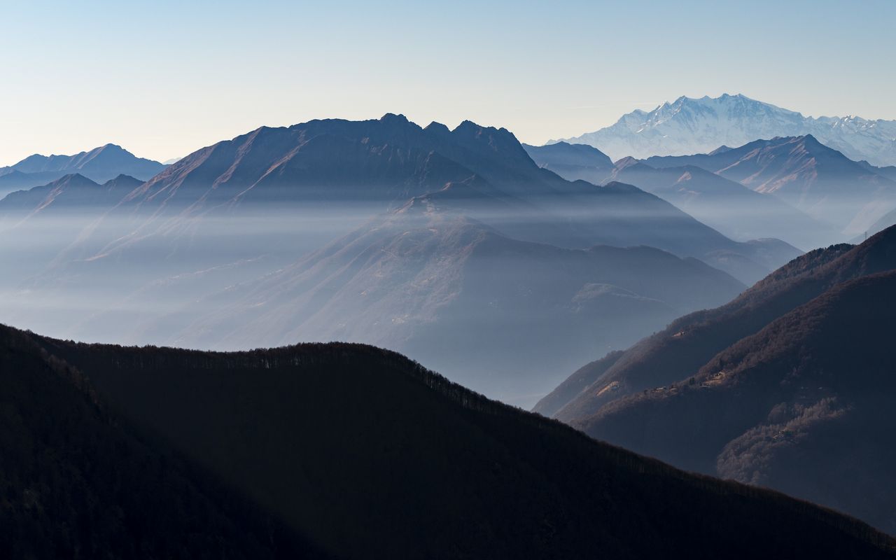
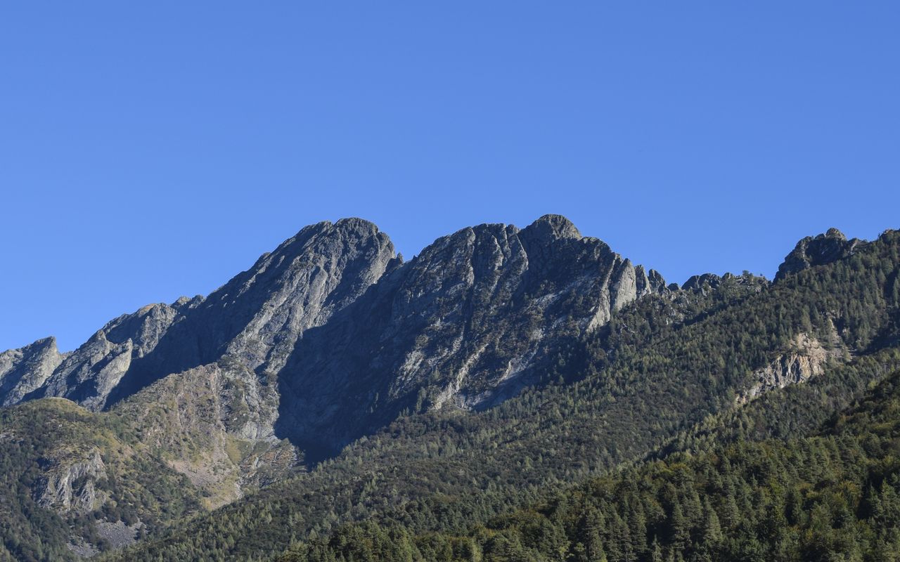
An overwhelming vantage point with a number of names

The highest point between Centovalli and Lago Maggiore is called “Gridone o M. Limidario” on the Swiss map. However, if you ascend through Val di Bordei to the summit, you will find Ghiridone painted on prominent boulders. So, what is the correct name? Both. Very often in the Ticino canton more than one name is in use, one in the local dialect and another in the standard Italian language. While Ghiridone is the standard name used by many in the region around Locarno and Centovalli, the people from Brissago prefer calling the mountain Gridone in their dialect, formerly also Cridone or Gredone. Monte Limidario is used on the Italian side of the border and is derived from the Latin word “limes” (border). But it may not have denoted today’s border between Switzerland and Italy, but the boundary line between pastures and rock.

Route description

Rasa – Bordei
Descend south through the quiet and well-preserved mountain village and past the monumental church of Terra Vecchia. Cross the creek at P. 663 and ascend gently to Bordei (726 m).
Bordei - Gridone
From Bordei ascend about 5 minutes on the small road until in the bend at 780 m the hiking trail branches off right into Val di Bordei, crossing shortly afterwards the rushing creek on a wooden bridge at P. 789. The trail leads around some boulders ascending gently through the fairly wide and shady valley floor until at ca. 880 m it crosses the creek again to reach the other side of the valley. Now the valley narrows, and the trail ascends more steeply southward, traverses a tributary creek at around 1060 m and zigzags up through brushwood to the small hunter shed (ca. 1380 m). It is mostly open and offers welcome shelter in case of a sudden weather change. However, as it is humid and grubby inside, it is not inviting enough for a longer stay. Afterwards the trail crosses the main creek yet again. From P. 1433 on the trail continues on a ridge interspersed with bushes via P. 1594. At an altitude of about 1800 m Val di Bordei widens to become a high plateau, from whose eastern edge one reaches Bocchetta di Valle (1948 m) in a wide arc. The spectacular view down to Lago Maggiore and further on to the Apennine range encourages taking a long break in the wide saddle. From Bocchetta di Valle many trails lead up to the mighty summit cross of Gridone. They all reach P. 1999. An interesting route is across some small rocky ledges and north-westward to reach the wide ridge at an altitude of ca. 2130 m. The last metres to the Gridone summit (2188 m) are unproblematic on schrofen, slightly on the Italian side of the ridge.
Gridone - Rifugio Al Legn
The descent from the summit to Capanna Al Legn follows the ridge until ca. 2130 m on the route of the ascent, then it continues on the ridge until shortly after the rocky outcrop at P. 2138, where you can descend to Bocchetta di Valle on a distinct rib. Following the markings hike eastward on a faint path to reach Rifugio Al Legn (1785 m) in a few minutes. It is located on a splendid terrace high above Lago Maggiore.

Additional information

Departure point

Rasa, Bergstation (898 m)

Informationen zur Seilbahn Verdasio - Rasa: www.ticino.ch/de/commons/details/Seilbahn-Verdasio-Rasa/1003.html

End point
Time

Rasa – Bordei 45 min.

Bordei – Bocchetta di Valle 3 h 30 min.

Bocchetta di Valle – Gridone 45 min.

Gridone – Rifugio Al Legn 45 min.

Difficulty / Material

There are hardly any technical difficulties on this route. In the spring snowfields in Val di Bordei between P. 1433 and 1800 m may make the ascent more difficult. Later in the year overgrowing bushes cover more and more of the path and markings. After heavy or long rainfall, the crossings of the creeks in the upper Val di Bordei may become problematic.

Waypoints

Bordei (726 m)

Quaint, nicely renovated village in Centovalli without any public transportation. Accommodation at Osteria Bordei (www.bordei.ch)

Bocchetta di Valle (1948 m)

Easy passage from Centovalli to Lago Maggiore

Author

Remo Kundert

Remo Kundert is a hiking guide and owner of the hiking tour operator Per Pedes Bergferien. He also works as a freelance photographer and alpine journalist, and has co-authored numerous hut guidebooks, alpine- and family hiking books.

Our recommendations

Primo soccorso

Ausbildung

Primo soccorso

Price CHF 39.00
Member price CHF 33.00
SAC-Crocs

Equipment

SAC-Crocs

Price CHF 59.00
Member price CHF 49.00
Tourenportal/App-Abo Jahreszahlung

Subscription to the SAC Route Portal

Tourenportal/App-Abo Jahreszahlung

Price CHF 49.00
SAC-Hütten-Monopoly

At home

SAC-Hütten-Monopoly

Price CHF 69.90
Member price CHF 60.00
Klettern Tessin / Ticino

Klettern

Klettern Tessin / Ticino

Price CHF 64.00
Member price CHF 54.00
SAC-Taschenmesser

Equipment

SAC-Taschenmesser

Price CHF 54.00
Member price CHF 49.00
Hütten der Schweizer Alpen / Cabanes des Alpes suisses

Bildbände

Hütten der Schweizer Alpen / Cabanes des Alpes suisses

Price CHF 69.00
Member price CHF 59.00
feedback