From Gelmersee | Mountain hiking | Swiss Alpine Club SAC
Unterstütze den SAC Jetzt spenden

From Gelmersee (Normal route) Ofenhoren (Gelmer) 2948 m

  • Difficulty
    T4+
  • Ascent
    4 h, 1170 m
  • Descent
    2:45 h, 1170 m

In red rocks above Grimsel granite

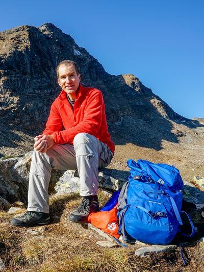
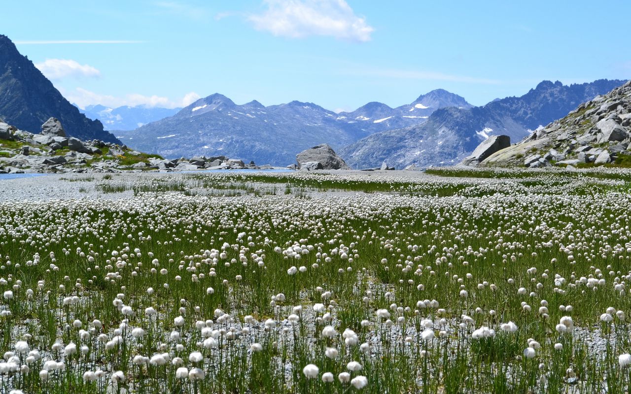
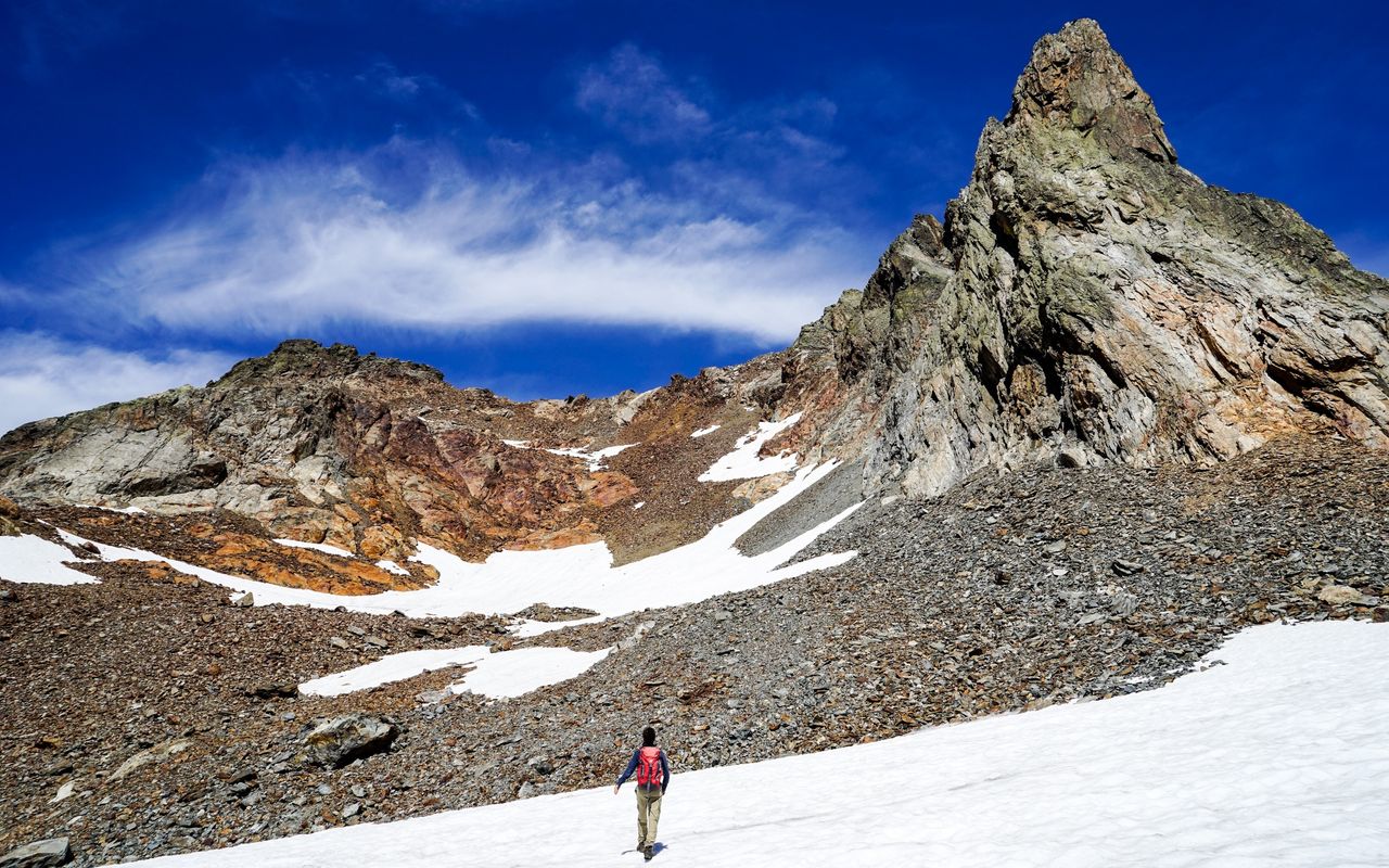
When climbing Ofenhoren in the Gelmer area, one hikes a considerable part of the route on scree and in boulder fields, but the effort pays off. Mighty jagged rocks tower left and right of the route, red amphibolite lets Ofenhoren shine as if on fire, and summiteers enjoy a vertiginous view to the Guttannen village 2000 metres down below. The alluvial plain Obrist Diechter, one of the gems of the Grimsel area, is a destination in its own right. From there Ofenhoren can already be seen, and it is hard to believe that it is so easy to climb.

Route description

From Gelmersee to Gelmerhütte
From Gelmersee follow the marked high mountain trail along the north shore of Gelmersee (some exposed passages), then climb the steep path up to Gelmerhütte (2411 m). The cabin is about half way up to Ofenhoren so that the tour can be spread over two days. Those who make it a one-day trip must keep an eye on the schedule of the Gelmerbahn and the bus, limiting their rest breaks to a minimum. After the rockslide in the summer of 2017 it is possible that the trail along the southern shore of the lake must be used. Add 30 min. of walking time.
Gelmerhütte – Ofenhoren – Gelmerhütte
Behind Gelmerhütte follow the trail. On a bifurcation branch off left; you will find «Ofenh.» painted on a boulder. The faint trail leads you to the beautiful alluvial plain Obrist Diechter with its several creeks, sandbanks and cotton grass fields. The alluvial plain changes every year so consider the following description as a guideline: walk around the plain on the right-hand (eastern) side. On its northern end cross a creek and turn left (west) before the scree walls. Now on the western rim of the plain cross another series of small creeks and follow the left (western) creek to the scree slope below Üssri Garwiidilimi. Begin the ascent on this scree slope rather on the northern rim close to the rocks, where you find a faint trail and cairns. Now ascend on these scree slopes and block fields west- and northward up to Üssri Garwiidilimi (2684 m). Continue the ascent on the broad scree ridge towards Ofenhoren, then walk left (west) of the Ofenhoren south ridge on névés and scree to a depression. Hike increasingly steeply towards the southwestern ridge, then climb the last part keeping to the left-hand side before exiting on the ridge proper. There are some old, blue marks, which do not help much. Now it pays off to ascend along the ridge to the secondary summit (2933 m), which offers a splendid view into Haslital and Guttannen deep below. Now take a few steps down and then up again to the main summit; at the end easy climbing is required. Descend back to the cabin on the same itinerary, without the detour to the secondary summit, of course. In any case it is better to go back on the south-western ridge, before descending in the scree depression.
From Gelmerhütte to Gelmersee
From Gelmerhütte hike back to Gelmersee on the marked mountain hiking trail.
Alternative: around Gelmersee
On the descent walk around Gelmersee on its south shore. Very beautiful, add roughly 30 mins., T3–.
Ascent from Künzentännlein
Ascent without using Gelmerbahn: from the bus station Kunzentännlein hike up to Gelmersee. Add another hour.

Additional information

Departure and arrival point

Gelmersee, Bergstation (1893 m)

It is essential to buy tickets online in advance, otherwise you may have to wait a long time and there may not even be any seats left for the whole day: www.grimselwelt.ch/bahnen/gelmerbahn

Difficulty / Material

One encounters a lot of scree, sometimes only faint trails and every now and then a cairn. Thus bad visibility makes orientation difficult. Under the summit there are short scrambling passages, where the help of the hands is needed. Surefootedness in loose rubble is important. After the rockslide in the summer of 2017 it is possible that the trail along the southern shore of the lake must be used.

Waypoints

Gelmerhütte SAC (2412 m)

The cabin is about half way up to Ofenhoren so that the tour can be spread over two days.

Üssri Garwiidilimi (2685 m)

Col on the way to Ofenhoren

Handegg, Kunzentännlein (1597 m)

Starting point for the alternative ascent without Gelmerbahn

Authors

Fredy Joss

Sabine und Fredy Joss

Alpine hiking, climbing and other mountain sports Sabine and Fredy Joss's passion. They have been writing and photographing for the SAC publishing house and the club magazine Die Alpen for many years. Sabine is also a biologist and tour guide; Fredy a proofreader and editor for various magazines.

Sabine Joss

Our recommendations

Skitouren Berner Alpen Ost

Skitouren

Skitouren Berner Alpen Ost

Price CHF 44.00
Member price CHF 34.00
SAC-Crocs

Equipment

SAC-Crocs

Price CHF 59.00
Member price CHF 49.00
Klettern Kombipaket Berner Oberland

Klettern

Klettern Kombipaket Berner Oberland

Price CHF 98.00
Member price CHF 79.00
Tourenportal/App-Abo Jahreszahlung

Subscription to the SAC Route Portal

Tourenportal/App-Abo Jahreszahlung

Price CHF 49.00
Gipfelziele Berner Oberland Grossformat

Berg- und Alpinwandern

Gipfelziele Berner Oberland Grossformat

Price CHF 54.00
Member price CHF 45.00
SAC-Hütten-Monopoly

At home

SAC-Hütten-Monopoly

Price CHF 69.90
Member price CHF 60.00
SAC-Taschenmesser

Equipment

SAC-Taschenmesser

Price CHF 54.00
Member price CHF 49.00
feedback