Traverse from east to south-west | Mountain hiking | Swiss Alpine Club SAC
Unterstütze den SAC Jetzt spenden

Traverse from east to south-west Pizzo Centrale 2999 m

  • Difficulty
    T5
  • Ascent
    3:45 h, 1000 m
  • Descent
    2 h, 1000 m

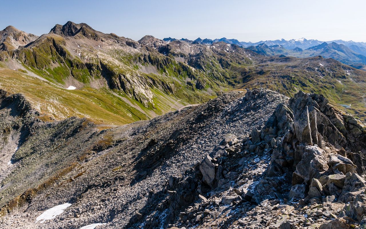
To the high point of Gotthard – but in an unusual way

Once upon a time Gotthard was considered the highest peak of the Alps. What would then be the highest peak above Gotthard, Pizzo Centrale? The question could make you ponder, but let’s drop the subject. From the many routes leading to Pizzo Centrale we have selected a rather unusual one, which also rewards mixed groups: those who take it easy leave Val Prevat to the ambitious, and at the summit the two groups meet to enjoy the view and undertake the descent together.

Route description

Passo del San Gottardo – Cascina di Val Torta
From the hospice on Gotthardpass (2091 m) follow the tarred road to Lago della Sella and hike across the dam. At its end leave the trail and walk past the army barracks at 2296 m to the end of the lake, where you cross the creek «La Sella» on a bridge close to Cascina di Val Torta.
Cascina di Val Torta – Rotstocklücke
After the bridge do not turn left to the Cascina (farm house), but follow briefly the creek upstream and then hike pathless above the rocky ditch into Val Prevat. From around 2460 m you can ascend directly along the creek. The last metres to the small lake at P. 2575 are overcome in an arc to the right or the left. If the old snow is completely melted away (or frozen enough to carry your weight), you can scramble up through the gorge proper to reach the lake. Hike pathless along the western shore into the narrow scree valley below Rotstocklücke. The little valley is surprisingly easy to hike up. If there is old or avalanche snow left, which can be the case well into the summer, the use of an ice-axe or even crampons can be helpful. Or else you can bypass the valley on the north side across lawn, rubble or block slopes.
Rotstocklücke – Pizzo Centrale
From Rotstocklücke (2785 m) to Pizzo Centrale follow the ridge. At first it is occasionally full of blocks, then it is a grassy crest with a faint path, and finally it is narrow and rocky. On the first segment the difficulties are bypassed through the south face to come back to the ridge line. Descending from P. 2897 you encounter a slabby and exposed climbing passage. The rocky outcrop at the first shoulder of Pizzo Centrale is bypassed on a faint path in the south face (exposed, but easy). Now follows the crux: the descent from the east summit (2986 m). Scrambling skills are required again, and the passage is exposed. On gentle terrain you finally reach the main summit (2999 m).
Pizzo Centrale – Lago della Sella
A distinct path helps on the descent to Guspissattel, then it leads southward below Gamsspitz / Tritthorn to a ridge and into the next natural terrain unit. At times the path is almost invisible, but the cairns will not let you down. After Sasso di Paisgion you meet the marked trail and descend to the shores of Lago della Sella.
Lago della Sella – Passo del San Gottardo
Now follow the road down the valley to the dam and on the road of the ascent hike back to Passo del San Gottardo.

Additional information

Departure and arrival point

Gotthard Hospiz / Passhöhe (2091 m)

Bus service only in the summer half-year.

Time

Passo del San Gottardo – Pizzo Centrale 3 h 45 Min.

Pizzo Centrale – Passo del San Gottardo 2 h.

Difficulty / Material

The ascent through Val Prevat is pathless, but not really difficult (T3+). The subsequent long ridge has a few scrambling and two difficult passages: one on the descent from P. 2897 (T5–) and one on the descent from the eastern summit (P. 2986) of Pizzo Centrale (T5). All these key passages can be done with a short climbing rope and some runners, if necessary. The descent from the main summit to Gotthardpass is around grade T3. If the ascent to Rotstocklücke is still snow-covered, an ice-axe (or even crampons) can be helpful.

Waypoints

Rotstocklücke (2785 m)

Saddle between Val Prevat and Gafallental

Neighbor summit

Pizzo Prevat (2876 m)

Rather a target for collectors than pleasure seekers. From Rotstocklücke follow the steep rubbly ridge (T4, round trip 30 min.).

Author

Marco Volken

Marco Volken is a freelance photographer and alpine journalist. He has co-authored numerous books on the Alpine region, including illustrated books, non-fiction books, hut guides, hiking and club guides, ski touring and climbing guidebooks.

Our recommendations

Gipfelziele Zentralschweiz Vierwaldstättersee

Berg- und Alpinwandern

Gipfelziele Zentralschweiz Vierwaldstättersee

Price CHF 54.00
Member price CHF 45.00
Primo soccorso

Ausbildung

Primo soccorso

Price CHF 39.00
Member price CHF 33.00
SAC-Crocs

Equipment

SAC-Crocs

Price CHF 59.00
Member price CHF 49.00
Tourenportal/App-Abo Jahreszahlung

Subscription to the SAC Route Portal

Tourenportal/App-Abo Jahreszahlung

Price CHF 49.00
SAC-Hütten-Monopoly

At home

SAC-Hütten-Monopoly

Price CHF 69.90
Member price CHF 60.00
Klettern Tessin / Ticino

Klettern

Klettern Tessin / Ticino

Price CHF 64.00
Member price CHF 54.00
SAC-Taschenmesser

Equipment

SAC-Taschenmesser

Price CHF 54.00
Member price CHF 49.00
Schneeschuhtouren Zentralschweiz

Schneeschuhtouren

Schneeschuhtouren Zentralschweiz

Price CHF 59.00
Member price CHF 49.00
Ausbildung Bergwandern / Alpinwandern

Ausbildung

Ausbildung Bergwandern / Alpinwandern

Price CHF 59.00
Member price CHF 49.00
Hütten der Schweizer Alpen / Cabanes des Alpes suisses

Bildbände

Hütten der Schweizer Alpen / Cabanes des Alpes suisses

Price CHF 69.00
Member price CHF 59.00
feedback