Seebodenalp - "Arschbaggen" - Rigi Kulm - Leiterliweg – Seebodenalp | Mountain hiking | Swiss Alpine Club SAC
Unterstütze den SAC Jetzt spenden

Seebodenalp - "Arschbaggen" - Rigi Kulm - Leiterliweg – Seebodenalp Rigi Kulm 1797 m

  • Difficulty
    T5-
  • Ascent
    2:15 h, 960 m
  • Descent
    2:30 h, 960 m

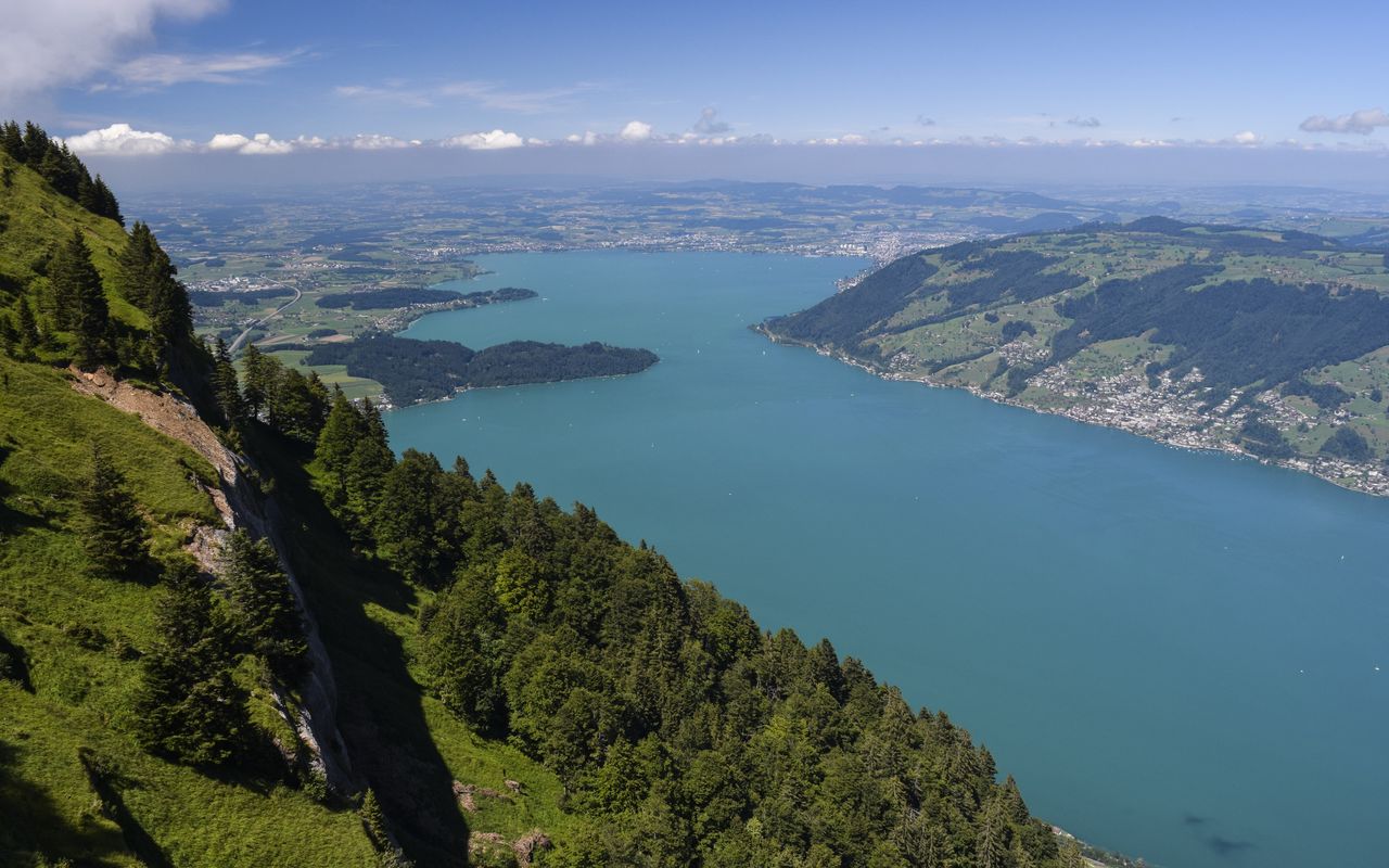
Rigi: via Arschbaggen (ass cheeks) to Rigi Kulm - and down on the Leiternwegli (ladder trail)

In a description from 1479 the deacon of the Einsiedeln monastery called Rigi «mons regina». In later texts Rigena, Riginun or Rigam are mentioned. They are all derived from «Riga», Latin for „line“, „trait“, „rock belt“, or „fold“. Scientists of today see the origin of the name Rigi in the „Rigenen“, those clearly distinguishable rock belts on the north and west sides of Rigi Kulm. Rigi is undisputedly an attractive mountain for alpine hiking. Proof are the ascent and especially the descent, which are far away from the daily hubbub of mass tourism.

Route description

Seebodenalp – Ronenboden
From Seebodenalp (1020 m) hike to Grodstafel, continue to Schwändi and along the forest edge up to Ronenboden.
Ronenboden – Tristenboden
From Ronenboden the trail ascends steeper to reach a bifurcation in Flüewald after traversing a first rocky ledge at ca. 1370 m. Go straight on and leave the forest to meet a rocky ledge charted on the map at about 1530 m, where the terrain gets distinctively steeper. You stand before the Arschbaggen or Füdlebaggen (ass cheecks), as this passage is often called. A fixed rope with thick knots for better grip helps to overcome the 15 m high, fairly slippery nagelfluh step to reach Tristenboden at 1579 m.
Tristenboden - Rigi Kulm
At the bench on Tristenboden a grassy path begins aiming directly at Rigi Kulm’s radio tower. At roughly 1700 m a last ledge of nagelfluh needs to be negotiated with the help of steel cables and iron rungs. It is the last of the major difficulties. The trail goes eastward and ascends zigzagging in the gentle meadows to the vast summit area, which you reach about 100 m east of the radio tower after climbing over a fence.
Rigi Kulm - Buechzingelflue
The descent from Kulm at first goes north-eastward on the marked mountain hiking trail, then turns right and leads via Zingel to the signpost at P. 1285 at the forest edge below Blatten. Here turn left and go along an impressive rock wall, gently keeping northward, then ascending north-westward until Buechzingelflue.
Buechzingelflue - Grasselen - Ober Stockbann
After Buechzingelflue cross a creek at ca. 1430 m and shortly afterwards choose the trail which descends to the right and zigzags to a rocky ledge. Aided by the slightly overgrown iron rungs and steel cables the ledge is overcome elegantly and without any problem. The trail now descends south-eastward to about 1140 m, where it turns left again. After crossing another creek, ignore the first bifurcation towards the valley but choose the second, which leads north-westward. The following rocky ledge is overcome with the help of a roughly 30 m high, not completely vertical ladder.
Ober Stockbann - Seebodenalp
At the foot of the ladder you soon come across the large hiking trail leading to the building at Oberstock. Shortly before Oberstock take the small road to the left and hike to Alpetli. Now branch off to the right, cross the creek, and here you are, back at the starting point at Seebodenalp.

Additional information

Departure and arrival point

Seebodenalp, Bergstation (1020 m)

Informationen zur Seilbahn Küssnacht am Rigi - Seebodenalp: www.rigi.ch/Media/Attraktionen/Luftseilbahn-Kuessnacht-Seebodenalp

Time

Seebodenalp – Rigi Kulm 2 h 15 min.

Rigi Kulm – Seebodenalp 2 h 30 min.

Difficulty / Material

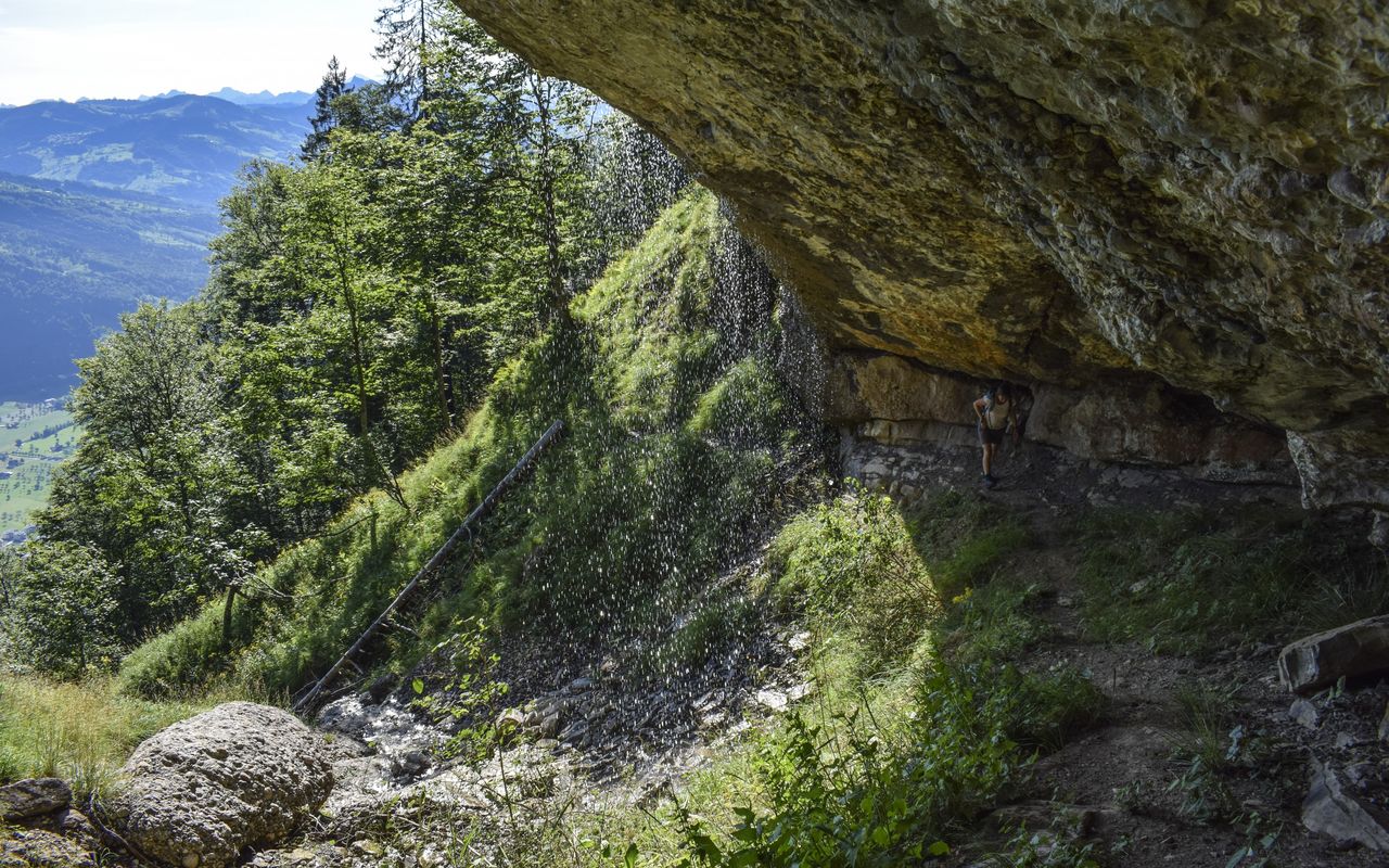
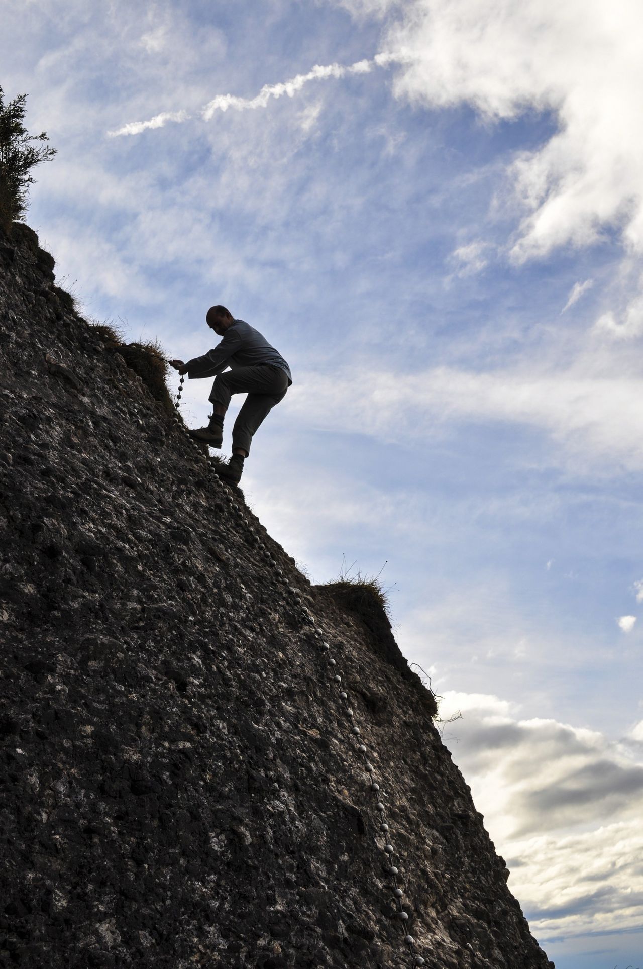
On the ascent there are various ledges made of a conglomerate rock called nagelfluh, which are equipped with good fixed ropes. The start of the first ledge, the highest and most challenging, is often wet. It goes 15 metres straight up and is fairly exposed. The other ledges are much easier.

The descent is somewhat easier (T4). On the stretch Buechzingelflue - Grässelen - Ober Stockbann the faint path on the Rigi north-east face is occasionally fairly overgrown, which requires orientational skill and surefootedness. Moreover, the trail has steep, rocky passages. Iron rungs and ladders help to overcome these obstacles.

Author

Remo Kundert

Remo Kundert is a hiking guide and owner of the hiking tour operator Per Pedes Bergferien. He also works as a freelance photographer and alpine journalist, and has co-authored numerous hut guidebooks, alpine- and family hiking books.

Our recommendations

Gipfelziele Zentralschweiz Vierwaldstättersee

Berg- und Alpinwandern

Gipfelziele Zentralschweiz Vierwaldstättersee

Price CHF 54.00
Member price CHF 45.00
SAC-Crocs

Equipment

SAC-Crocs

Price CHF 59.00
Member price CHF 49.00
Tourenportal/App-Abo Jahreszahlung

Subscription to the SAC Route Portal

Tourenportal/App-Abo Jahreszahlung

Price CHF 49.00
SAC-Hütten-Monopoly

At home

SAC-Hütten-Monopoly

Price CHF 69.90
Member price CHF 60.00
SAC-Taschenmesser

Equipment

SAC-Taschenmesser

Price CHF 54.00
Member price CHF 49.00
Schneeschuhtouren Zentralschweiz

Schneeschuhtouren

Schneeschuhtouren Zentralschweiz

Price CHF 59.00
Member price CHF 49.00
Ausbildung Bergwandern / Alpinwandern

Ausbildung

Ausbildung Bergwandern / Alpinwandern

Price CHF 59.00
Member price CHF 49.00
Hütten der Schweizer Alpen / Cabanes des Alpes suisses

Bildbände

Hütten der Schweizer Alpen / Cabanes des Alpes suisses

Price CHF 69.00
Member price CHF 59.00
feedback