From Tällilücke and over the west ridge | Mountain hiking | Swiss Alpine Club SAC
Unterstütze den SAC Jetzt spenden

From Tällilücke and over the west ridge (Normal route) Gross Muttenhorn 3098 m

  • Difficulty
    T4+
  • Ascent
    3:30 h, 760 m
  • Descent
    2:30 h, 760 m

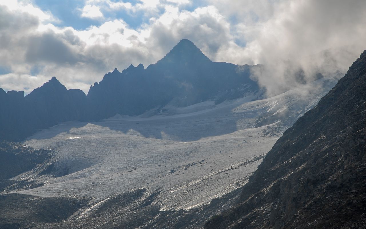
Ridge walk to an imposing pyramid

Gross Muttenhorn is the northernmost and highest peak of Muttenhörner. The towering summit is a relatively easy target for alpine hikers. The ridge walk with the beautiful view offers remnants of military activity and a few exposed passages. From the summit you have a surprising view to the Rotondo range in the south and to Galenstock in the north as well as down to the Rhone and Urseren valleys.

Route description

Furkapass – P. 2771 above Tälligrat
From Furkapass walk on a good trail west of Blauberg into the valley of Muttgletscher. The wide trail disappears in the moraine fields, but a hiking path leads to the bifurcation at P. 2503. From here ascend to Tällilücke and on to P. 2771 above Tälligrat (bifurcation with signpost; marked until this point).
P. 2771 above Tälligrat – Gross Muttenhorn
From P. 2771 on a distinct path hike slightly downhill around the south side of Tällistock to the ridge between Tällistock and Gross Muttenhorn. Now follow the occasionally exposed and eroding, but large west ridge of Gross Muttenhorn up and down to the rocky structure of P. 2985. Ca. 100 m after this point jagged rocks bar the way on the ridge. A faint path leads around theses rocks: 30 metres up and down on the south side on steep and partly slippery slopes. Behind the jagged rocks continue on the ridge to the summit.
Descent
Descend on the same route back to Furkapass.
Variant from Oberwald to Gross Muttenhorn
From Oberwald hike via Hungerberg, Gale and Tälligrat to the main route and the bifurcation at P. 2771. 5 h from Oberwald station to the summit.

Additional information

Departure and arrival point

Furka Passhöhe (2429 m)

Busbetrieb nur im Sommerhalbjahr.

Difficulty / Material

There is a marked mountain hiking trail until below Tällistock, then you find paths and intermittent faint paths up to the summit. The difficulties might increase in the future due to the eroding terrain.

Waypoints

Tällilücke (2719 m)

Tällilücke is crossed on the hike to Gross Muttenhorn.

Oberwald, Bahnhof (1366 m)

Starting point for the variant

Neighbor summit

Tällistock (Goms) (2878 m)

On the way to Gross Muttenhorn. From P. 2771 it is traversed on the grassy ridge with a few rocks. T4.

Author

Fredy Joss

Sabine und Fredy Joss

Alpine hiking, climbing and other mountain sports Sabine and Fredy Joss's passion. They have been writing and photographing for the SAC publishing house and the club magazine Die Alpen for many years. Sabine is also a biologist and tour guide; Fredy a proofreader and editor for various magazines.

Our recommendations

Walliser Alpen

Alpine Touren

Selection guide

Walliser Alpen

Price CHF 49.00
Member price CHF 39.00
Gipfelziele Zentralschweiz Vierwaldstättersee

Berg- und Alpinwandern

Gipfelziele Zentralschweiz Vierwaldstättersee

Price CHF 54.00
Member price CHF 45.00
SAC-Crocs

Equipment

SAC-Crocs

Price CHF 59.00
Member price CHF 49.00
Tourenportal/App-Abo Jahreszahlung

Subscription to the SAC Route Portal

Tourenportal/App-Abo Jahreszahlung

Price CHF 49.00
SAC-Hütten-Monopoly

At home

SAC-Hütten-Monopoly

Price CHF 69.90
Member price CHF 60.00
SAC-Taschenmesser

Equipment

SAC-Taschenmesser

Price CHF 54.00
Member price CHF 49.00
Bergsport Sommer

Ausbildung

Bergsport Sommer

Price CHF 59.00
Member price CHF 49.00
Schneeschuhtouren Zentralschweiz

Schneeschuhtouren

Schneeschuhtouren Zentralschweiz

Price CHF 59.00
Member price CHF 49.00
Ausbildung Bergwandern / Alpinwandern

Ausbildung

Ausbildung Bergwandern / Alpinwandern

Price CHF 59.00
Member price CHF 49.00
Hütten der Schweizer Alpen / Cabanes des Alpes suisses

Bildbände

Hütten der Schweizer Alpen / Cabanes des Alpes suisses

Price CHF 69.00
Member price CHF 59.00
feedback